The user of this information should always consult official FEMA flood maps and certified elevation data if there is any doubt of a property's flood risk. Please consult with your local, county, and/or community floodplain administrator for availability of official DFIRMs in your county. These maps are available online at http://www.msc.fema.gov .
1. Identify your location: use the seach tool or pan/zoom
2. Click on identified location to view floodplain and related information
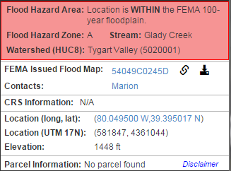
3. View Query Results
Latitude | Longitude | |
![]() |
||
![]() |
The share link includes following parts:
1. URL of the application: http://www.mapwv.gov/flood/map/index.html
2. For parcel share link, parameter pid is required.
Format: Cnty(2)District(2)MAP(4)PARCEL(4)Suffix(4)Special(4)
3. For address share link, parameter address is required.
e.g., 98 Beechurst Ave, Morgantown, WV 26506
4. For coordinate share link, five parameters.
4.1 wkid-spatial reference. Format: wkid=4326
4.2 x coordinate (based on wkid). Format: x=123
4.3 y coordinate (based on wkid). Format: y=123
4.4 l-zoom level (between 0 and 12)(optional). Format: l=5
4.5 v-map view (0-public, 1-expert, 2-risk)(optinal). Format: v=1
Building ID Format | CC-DD-MMMM-PPPP-SSSS_Address |
Actual Part Name | County-District-Map-Parcel-Suffix_Address |
Sample Building ID | 01-08-0011-0069-0000_604 |
Geographic Name | USGS Quad | Type |
---|
Depth |
---|
0 Foot |
1 Foot |
2 Feet |
3 Feet |
4 Feet |
5 Feet |
6 Feet |
7 Feet |
8 Feet |
9 Feet |
10 Feet |
11 Feet |
12 Feet |
13 Feet |
14 Feet |
15 Feet |
>15 Ft |